Meteorology

Table of Contents:
The Weather Channel, already a
tremendous source for current weather data, and "meteorological
tidbits" has added an education area to its website. To access go
to:
http://www.weather.com
Weather World, sponsored by a University
Park TV station, examines the science of weather forecasting and
discusses current meteorological topics.
http://www.ems.psu.edu/WeatherWorld/
Looking for a site with current
weather data (available soon) AND an
outstanding tutorial section? Be sure to visit the
WW2010 WEATHER SITE at the
University of Illinois at Urbana-Champaign
(UIUC). This site provides diagrams and text to support topics
including fronts, clouds, severe weather and much more. Additionally,
case studies of Hurricane Andrew and Superstorm '93 are archived
here.

http://ww2010.atmos.uiuc.edu/(Gh)/home.rxml
USA
Today has created an excellent site with thorough information
on weather and other science related
topics. Many fine diagrams and illustrations are utilized to support
the content addressed on each topic. This site has a teacher page and
has info appropriate for middle and high school students.
http://www.usatoday.com/weather/wfront.htm
The American Meteorological Society has
developed a weather education website associated with a professional
development initiative called the Datastreme Project. This website
has tremendous resources that every science educator can make use of.
Would you like a current surface plot of weather conditions across
the U.S.? Its available here! Would you like that with all data
plotted? just temperature reports? temperature reports with
isotherms? pressure reports only? pressure reports with isobars? Get
the idea? Using this site, YOU choose the degree of sophisitication
and detail that you want to present to your students. Images accessed
here can be saved for general classroom use OR printed for individual
student use. Satellite and upper air data is also available. All
images load quickly so that even a slow Internet connection will be
able to take advantage of this site.
http://atm.geo.nsf.gov/dstreme/

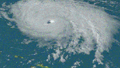
The Miami Museum of Science has developed
a comprehensive website about
HURRICANES. Although it is geared
towards elementary school age students, it has some features that
could be of great value to teachers of middle and high school
students. Specifically, from the home page, link to "Killer Storms"
and you will find two worthwhile features. Linking on the hurricane
warning flags brings the viewer to a list of watches and warnings
that may be issued in advance of an approaching tropical system.
Linking on the radar screen takes you to an interactive exercise
where you can track and plot a hurricane. This exercise provides
excellent practice in locating a point by latitude and longitude.
Consider the possibilities in a mapping unit, regardless of the
theme!
http://www.miamisci.org/hurricane/
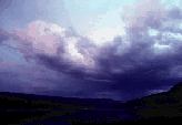
For a nice description of how
SEA BREEZES form and a descriptive
series of diagrams, visit the USA-Today site linked below.

http://www.usatoday.com/weather/wseabrze.htm
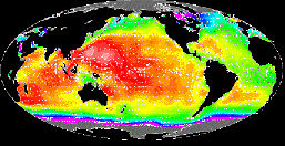
The University of Wisconsin&emdash;SSEC has
probably the best collection of real time and near real time images
available on the web today. At this site, you can download the latest
GOES satellite images. Each is presented in great detail. One
warning: the downloads often exceed 300k, thus taking time if you
have a slow Internet connection. If you are looking for spectacular
sea surface temperature (SST) images, this is truly the place! The
site also maintains a volcano watch of the world's ten most active
volcanoes.
http://www.ssec.wisc.edu/data/
NATIONAL WEATHER SERVICE
FORECAST OFFICES from all over the nation can be accessed from
this site. Look for the office near you, link to it and discover what
resources they have posted at their local site. Often you can access
updated weather forecasts, local warnings, and local data.
For residents of the Northeast, I highly recommend a visit to the
Albany, NY NWS site.
Current forecasts and data are available at this site for all
locations from Virginia to Maine. The CURRENT DATA section contains a
wealth of maps and images (satellite, radar, etc...) The FORECAST
DATA section contains access to most of the currently available
forecast models for those who wish to hone their own forecasting
skills! These models report both regional and national data.
Finally, an extensive RESEARCH section includes several case
studies of various weather events including the July 1995 "Super
Derecho" that occurred in the Adirondak Mountains.

http://www.ugems.psu.edu/~owens/nwsfo.html
Purdue University provides an outstanding
CURRENT WEATHER site. From the link below, you can access current
surface and upper air maps, satellite images (visible, IR, and water
vapor), computer forecast models, radar information (local and
national) as well as tutorials explaining how to interpret the images
and models. This is a very complete and educationally valuable
site.
http://wxp.atms.purdue.edu/
The VIRTUAL WEATHER MAP ROOM, maintained by
Prof. Jon Kahl of University of Wisconsin, Milwaukee provides a
wealth of CURRENT WEATHER DATA similar to that which is provided by
Purdue University. Prof. Kahl has even linked to some of the Purdue
WXP maps. He does have some unique features though, be sure to check
out the surface maps, current radar (he uses Intellicast), and snow
cover maps (seasonal)

http://www.uwm.edu/~kahl/106/106_wx.html
Looking to do a case study on a major
snowstorm? Check out this site,
where Cornell University has posted findings from the Blizzard of
1996 that impacted much of the Northeast. Having personally
experienced this one, I can vividly recall nearly 72 hours of
continuous snowfall with a final accumulation in excess of 30 INCHES
in Northern New Jersey! I distinctly recall my lawn chairs slowly
disappearing into a sea of white!
http://met-www.cit.cornell.edu/blizzard96.html